# leaflet-measure
**Repository Path**: opengis-leaflet/leaflet-measure
## Basic Information
- **Project Name**: leaflet-measure
- **Description**: No description available
- **Primary Language**: Unknown
- **License**: MIT
- **Default Branch**: master
- **Homepage**: None
- **GVP Project**: No
## Statistics
- **Stars**: 1
- **Forks**: 0
- **Created**: 2021-07-31
- **Last Updated**: 2021-10-26
## Categories & Tags
**Categories**: Uncategorized
**Tags**: None
## README
# leaflet-measure
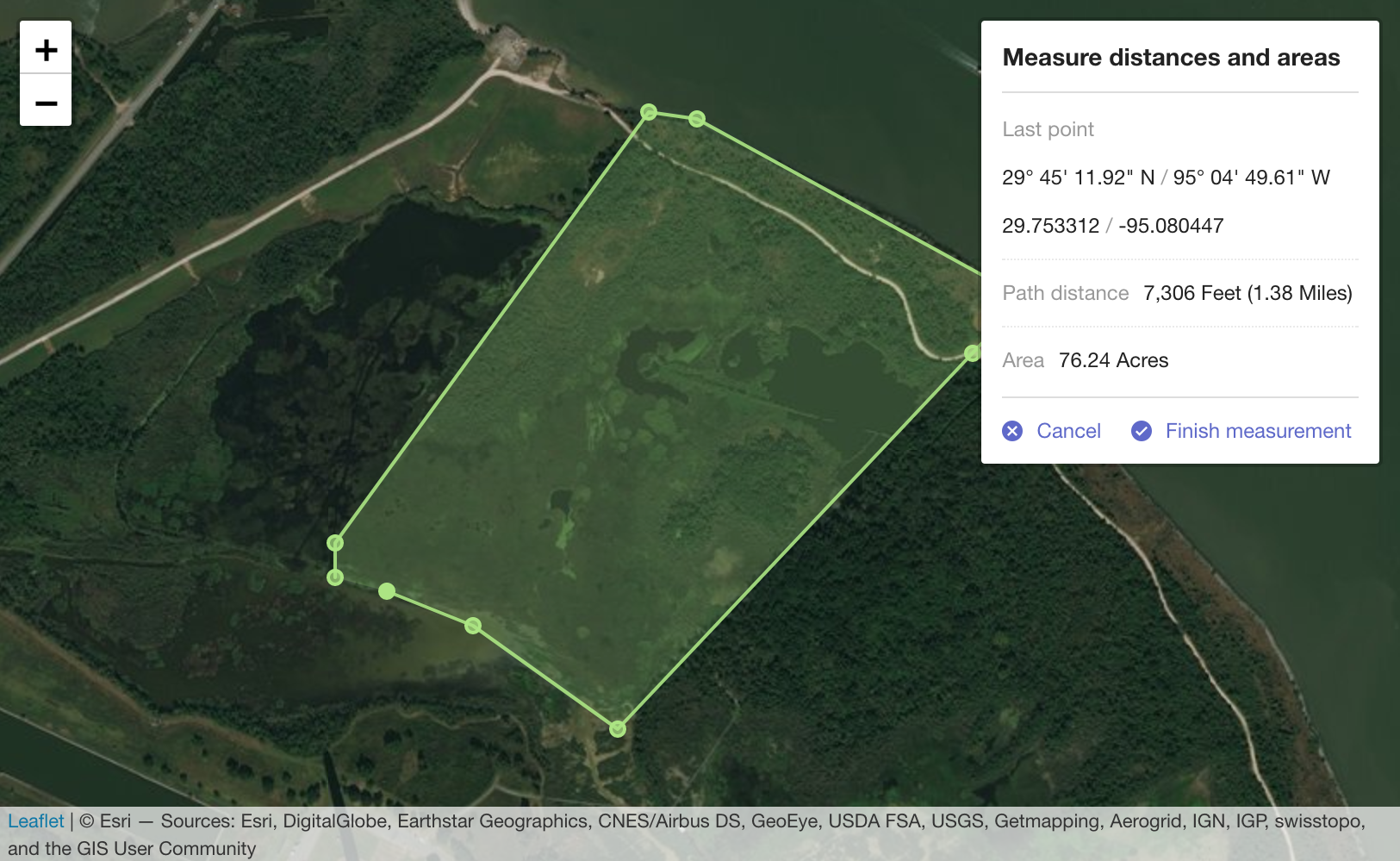
Coordinate, linear, and area measure control for [Leaflet](http://leafletjs.com) maps. Extends [L.Control](http://leafletjs.com/reference.html#control).
## [Demo](http://ljagis.github.io/leaflet-measure)

## Usage
TODO. Add usage
## Add control to a Leaflet map
`leaflet-measure` adds `L.Control.Measure`. This control may be used with the standard Leaflet control workflows [described in the Leaflet docs](http://leafletjs.com/reference.html#control).
The measure control can be instantiated directly and added to a map:
```javascript
var myMap = L.map('mapElementId', options);
var measureControl = new L.Control.Measure(options);
measureControl.addTo(myMap);
```
or instantiated via the factory:
```javascript
var myMap = L.map('mapElementId', options);
var measureControl = L.control.measure(options);
measureControl.addTo(myMap);
```
or added to a map using map options:
```javascript
var myMap = L.map('mapElementId', {
measureControl: true
});
```
## Control options
### position
`{ position: 'topright' }`
Standard Leaflet control [position options](http://leafletjs.com/reference.html#control-positions)
### primaryLengthUnit | secondaryLengthUnit
`{ primaryLengthUnit: 'feet', secondaryLengthUnit: 'miles' }`
Units used to display length results. `secondaryLengthUnit` is optional.
Valid values are `feet`, `meters`, `miles`, and `kilometers`
### primaryAreaUnit | secondaryAreaUnit
`{ primaryAreaUnit: 'acres', secondaryAreaUnit: undefined }`
Units used to display area results. `secondaryAreaUnit` is optional.
Valid values are `acres`, `hectares`, `sqfeet`, `sqmeters`, and `sqmiles`
### activeColor
`{ activeColor: '#ABE67E' }`
Base color to use for map features rendered while actively performing a measurement. Value should be a color represented as a hexadecimal string.
### completedColor
`{ completedColor: '#C8F2BE' }`
Base color to use for features generated from a completed measurement. Value should be a color represented as a hexadecimal string.
### popupOptions
`popupOptions: { className: 'leaflet-measure-resultpopup', autoPanPadding: [10, 10] }`
Options applied to the popup of the resulting measure feature. Properties may be any standard Leaflet [popup options](http://leafletjs.com/reference.html#popup-options).
### units
Custom units to make available to the measurement calculator. Packaged units are `feet`, `meters`, `miles`, and `kilometers` for length and `acres`, `hectares`, `sqfeet`, `sqmeters`, and `sqmiles` for areas. Additional unit definitions can be added to the packaged units using this option.
Define units as
```javascript
{
someNewUnit: {
factor: 0.001, // Required. Factor to apply when converting to this unit. Length in meters or area in sq meters will be multiplied by this factor.
display: 'My New Unit', // Required. How to display in results, like.. "300 Meters (0.3 My New Unit)".
decimals: 2 // Number of decimals to round results when using this unit. `0` is the default value if not specified.
},
myOtherNewUnit: {
factor: 1234,
display: 'My Other Unit',
decimals: 0
}
}
```
### captureZIndex
`{ captureZIndex: 10000 }`
Z-index of the marker used to capture measure clicks. Set this value higher than the z-index of all other map layers to disable click events on other layers while a measurement is active.
### decPoint | thousandsSep
`{ decPoint: '.', thousandsSep: ',' }`
Decimal point and thousands separator used when displaying measurements. If not specified, values are defined by the localization.
## Events
You can subscribe to the following events on the [Map](http://leafletjs.com/reference.html#map-class) using [these methods](http://leafletjs.com/reference.html#events)
### measurestart
Fired when measurement starts
### measurefinish
Fired when measurement finishes with results of the measurement. Results data includes:
- `area`: Area of a polygon measurement in sq meters. 0 for measurements with less than 3 points.
- `areaDisplay`: Area formatted as displayed in the popup.
- `lastCoord`: Last point clicked in both decimal degrees and degress/min/seconds.
- `length`: Length of the measurement in meters. 0 for measurements with less than 2 points.
- `lengthDisplay`: Length formatted as displayed in the popup.
- `pointCount`: Number of points directly added by the user.
- `points`: Array of points as [`LatLng`](http://leafletjs.com/reference.html#latlng) used to calculate the measurement. Number of items in the array may differ from `pointCoint` because an additional point is added to close polygons during polygon measurements.
## Customizing map feature styles
Map features may be styled using CSS SVG style attributes. Features generated from `leaflet-measure` measurements are given the following class names:
- **layer-measurearea**: Feature displaying area of an active measurement
- **layer-measureboundary**: Feature displaying the linear path of an active measurement
- **layer-measurevertex**: Feature added at each vertex (measurement click) of an active measurement
- **layer-measuredrag**: Symbol following cursor while moving during an active measurement
- **layer-measure-resultarea**: Feature added to the map as a permanent layer resulting from an area (3+ points) measurement
- **layer-measure-resultline**: Feature added to the map as a permanent layer resulting from a linear (2 point) measurement
- **layer-measure-resultpoint**: Featured added to the map as a permanent layer resulting from a point (single click) measurement
## Development
The build process uses npm (Node Package Management) which comes with Node.js.
After you have Node.js installed you can do ```npm install``` to install dependencies and ```npm run-script start:dev``` to initialize a local server (localhost:8080) for leaflet-measure assets.
It detects modifications on source files and re-compiles to /leaflet-measure.css and /leaflet-measure.js.
## Distribuition Build
With npm installed do ```npm install``` to install dependencies and ```npm run-script build``` to generate dist/leaflet-measure.css and dist/leaflet-measure.js.
It will also generate dist/leaflet-measure.{locale}.js files for each localization available.
## Internationalization
TODO. Internationalization